Canadians working with statistical and research data include government documents librarians whom we find in most university research libraries.  Many government document librarians and their colleagues, the data librarians, participate in the Data Liberation Initiative (DLI) which I introduced in a post honouring one of its founders.  They are also often members of the Canadian Association of Public Data Users (CAPDU) among many other important data related organizations.  The DLI also does much capacity building for research, data and map librarians in yearly face to face meetings and online discussion, developing expertise which is then shared among colleagues in their home institutions.

Aspi Balsara is one of the government documents librarians at the Queen Elizabeth II Library, Memorial University of Newfoundland.  He is a CAPDU member and has been kind enough to share his latest FAQ about various initiatives to disseminate Statistics Canada data.  The post is technical and specific in nature, but demonstrates quite nicely the kind of expertise we have across Canada in this area, a knowledge base that is often overlooked.  The FAQ introduces many databases and formats while also answering new dissemination policy questions.

Finally, this post also introduces a data community of practice with experts who collaborate nationally to benefit their local users using LISTSERVs technology, which ain’t fancy, but sure is effective in a place like Canada with its smart people scattered all over a big geographical expanse.  Twitter does some things well, but these lists and their archives are invaluable in fostering near real time deep collaboration.  People get to meet face to face once a year thanks to the DLI, so the relationships are quite strong.

***********************

FAQ on various dissemination initiatives from Statistics Canada

1.     Are all Public Use Microdata Files (PUMFs) available to the public, or only some of them?  All PUMFs are available, free of charge.  This has been the case for the past year and a  half.

2.     How does the public access and order a PUMF?   The public may order it directly from the Statistics Canada homepage, using the Search the site feature.  After filling out the order form, the customer will then be contacted by Statistics Canada to sign a licence agreement.  Upon receipt, the data is put on CD-ROM and shipped.

3.     Do these freely available PUMFs include SPSS and SAS command files (as they do for DLI subscribers)?  The codes are generally available in SAS which is what Statistics Canada (SC) uses.  SPSS is used mainly by the academic sector. SPSS may be available sometimes, but when derived from SAS, its quality is questionable as it does not include “missing values”.  Eventually, through the Common Tool for Social Surveys, SC will have more standardized output, including good SPSS codes.

4.     Since PUMFs are now publicly accessible, what value do DLI subscribers get for their subscription?  Revenue from DLI subscriptions pays for the infrastructure, regional and national training for the DLI contacts, prompt support through the listserv, and other initiatives.   No money goes toward paying for the data. This has been emphasized at the DLI training “bootcamps” where DLI contacts are asked to convey to their library administration the value of the training and support available from the DLI.  This is also pointed out in the DLI annual reports.

DLI subscribing institutions can share a PUMF in a classroom or lab environment.  Otherwise, a professor would have to obtain a licence from Statistics Canada that each student would be required to sign before using the PUMF.

Through the DLI, member institutions also have access to the Discharge Abstract Database (DAD) Research Analytic Files from the Canadian Institute for Health Information (CIHI).  The Discharge Abstract Database is only available to DLI members (see no. 11 below).

5.     In November 2010, Statistics Canada announced its intention to launch a subscription service to all its PUMFs.   This service was targeted to non-Canadian subscribers for an annual fee of $5000.00.   Is there any information about it?  This service aims at national and international organizations outside the DLI who wish to access SC’s complete PUMF collection, be informed of new releases, and avail of a service that answers their queries.  This service is called the “Public Use Microdata File (PUMF) Collection”.

See: http://www.statcan.gc.ca/bsolc/olc-cel/olc-cel?catno=11-625-XWE&1ang=eng

6.     With free CANSIM access beginning February 1, 2012, will the CANSIM component in E-Stat continue to be provided?   If so, will it be updated more than just once a year? In April 2012, Statistics Canada announced that E-Stat would be archived on June 30,    2012. It was last updated July 2011 and will remain so until removed permanently on June 30, 2013. (In the meantime, E-Stat can be accessed by clicking Students and teachers in the left menu bar of Statistics Canada’s homepage.)  Hence, there is no point using the E-Stat version of CANSIM anymore.

Other resources on E-Stat, such as the 1996, 2001 and 2006 censuses can be accessed from: http://www12.statcan.gc.ca/census-recensement/index-eng.cfm as well as from the library webpages at:  http://guides.library.mun.ca/canadianstatistics  and http://guides.library.mun.ca/content.php?pid=207197&sid=1734802

A new web location has yet to be determined for Census years 1665-1871, 1986 and 1991, as well as environment and elections data (currently accessible via E-Stat).

7.     Is it just the CANSIM data that will be freely available as of February 1, 2012, or all of Statistics Canada’s data? In addition to CANSIM, select census data products for 2011 will be freely available.  Statistics Canada will maintain current pricing practices for print publications, maps, CD-ROMs and custom products and services.

See: http://www42.statcan.gc.ca/smr09/smr09_035-eng.htm

8.     Are the geography products also freely available? As of November 29, 2011, geography data from the 2006 and 2011 censuses are available free of charge except for postal code products since they are provided by Canada Post. As it stands, DLI member institutions have access to postal code information products that can only be used for research and teaching purposes and cannot be shared with non-DLI institutions.  While these products are freely available to DLI subscribers, it should be noted that Statistics Canada is presently negotiating with Canada Post for continued access to postal code products.  If and when an agreement is concluded, it will be added as an appendix to the DLI licence agreement.

 9.     Does the public have to pay for DA (Dissemination Area), Block level data (basic population and dwelling counts) and FSA (Forward Sortation Area) data?   Data for DAs – for 2011 and previous census years – are now available for free upon request.  This is why you will see a “contact us” link for census tables at the DA level (whereas previously there was a $ sign since these tables were not freely available).  Block level data is available at the population and dwelling count level from GeoSearch or GeoSuite, and there is no charge.  FSAs come under postal code data covered above in no. 8.

10.  The new DLI licence (sent to subscribing institutions in September 2012) no longer states explicitly that data are restricted to research and educational purposes only.  Does this mean that commercial use of the data is now permitted?   Firstly, the majority of Statistics Canada’s standard and custom products will be disseminated under the terms and conditions of the Statistics Canada Open Licence Agreement.   See:  http://www.statcan.gc.ca/reference/licence-eng.html   It permits a worldwide, royalty-free, non-exclusive licence to use, reproduce, publish, freely distribute, or sell the information. This means that standard data products once distributed by the DLI, such as Intercorporate Ownership, SABAL – Small Area Business and Labour Database can now be made accessible to the general public and not just the       university community. However, lifting the restriction on such data is left to the discretion of the DLI member institution since it is then obliged to shoulder responsibility for providing support to outside clients. Organizations that prefer to maintain the restriction may refer non-university users to Statistics Canada for assistance.

Postal products are still restricted to DLI members (as explained in no. 8 above).

Public Use Microdata Files (PUMFs) are covered in an appendix to the new DLI Licence Agreement. Basically, bona fide members of a DLI member institution may use a PUMF for commercial purposes but cannot provide the file to outside clients.  For instance, a professor may publish the findings from a PUMF in a text book, but may not reproduce the data or share it.  Similarly, she may submit research for a client that draws upon a PUMF but cannot include the data. Should the client wish to consult the PUMF, she would follow the procedure described in no. 2 above.

11.  When will CIHI (Canadian Institute for Health Information) add its files to the DLI?

Plans are under way to make the Discharge Abstract Database (DAD) available as a DLI file (see no. 4).  The DAD focuses on inpatient acute care discharge in Canada (excluding Quebec).   The files will be available to the DLI community through the DLI FTP site once all members have signed and returned the licence agreement distributed last September.

Aspi Balsara

Feb 14, 2012

Revised:  April 17, 2012;  May 4, 2012, October 15, 2012
Today, Statistics Canada released the head count and the dwelling count of the 2011 census, the 2011 Census, the shortest decennial census in the history of Canada, the 1st official census since confederation was taken in 1871. More data on age, relationships and language to follow, and uh that is it!
The Census is the only legislated instrument that counts everyone every 5 years. Surveys come and go, are not legislated and do not have designated budgets.

Also, Statistics Canada announced a short while ago that its data were going to be disseminated for free for the first time and under a new more open and less restrictive licence (G&M article, Embassy Magazine Article). This is really good news as cost recovery was a horrid policy instrument barring access to data that we by law had to give away. Restricted access only allowed for a small subset of the population to study, discuss and know about who Canadians are. It also meant that we were not getting collectively smarter.

I and many others were and remain concerned that we do not know what data exactly will be made available, at what level of geography, will cross tabulations and special orders such as by neighbourhood or ward be more expensive than before, will that licence be as open, and as Woolley observed, how the data are disseminated is of concern, since well, right now it is clunky at best.   We all do applaud the effort.

Upon playing with the data dissemination interface today, my concerns were re-affirmed.  The data are free but not necessarily accessible, in the sense that the methods used to disseminate and discover these is complicated, unclear and there are some favourite geographies missing – most notably Dissemination Areas (DA) while others are hidden – Census Tracts (CTs).

For example, if you go to the Census Profile and you want to look up 5 cities at once you cannot! You can only look up one city at a time, which also means you can only download one geography at a time.  There are over 2000 cities in Canada and if you want to know who the top 30 are in terms of population, then its “Houston we have a problem!” sorta.

Furthermore, once you look at your city, you are provided with Census Metropolitan Areas (CMAs), Census divisions (CDs) and Census Subdivisions (CSDs), economic region (ERs), electoral districts (FEDs) and population centres (POPCTR).  CTs are hard to find and DA data more so.  CTs and DAs are smaller geographies very helpful for sub city analysis.  Now, when you do get lets say FED data for your city, you only get provided with one district at a time and not the cities FEDs at once.   So,  have to go back and download them one at a time and then assemble the file.  CT and DA geographies are also not in this list.  You have to dig for those!

To get to CTs  (no DAs to be found yet)  my friend Sara a GIS expert at the Social Planning and Research Council of Hamilton made this discovery:

  1. Go here
  2. Click on Thematic Maps (scroll down),
  3. Go to CMA maps & choose your location.
  4. Then on the following page there will be a link to the map and a table with all the pop change values for each CT.

Alternatively, and again thanks to Sara you can do the following:

  1. Go here
  2. Then type in a random CT (you can use the example given at the bottom of the list).
  3. On the next page, click the CT number
  4. On the next page, click the download tab.
  5. Then scroll to Option 2, and select Census tracts and your data format,
  6. and “Continue” – Voila, it will download a file for population counts for all CTs in Canada!

Which is ah, absurd. First cuz, well that is a lot of clicking to get to what should be on the first page.  Second, what CTs are in my city?  This file organizes CTs into CMAs which are not CDs or CSDs.  CDs or CSDs correspond to the legal administrative boundaries of cities and municipalities.  CMAs are much larger geographies, they are a StatCan construct and are not an official administrative city or municipality.  You have to be an analyst or a good dictionary reader to know this.  Most people report CMA results, but those miss many cities and some cities are split.

Also, what if you want 5 cities at a time and not just one at a time?

Ted, the GIS expert at Community Development Halton, who was trying to join the CT data with his geomatics files discovered the following:

Unfortunately, the CT table is a mess for GIS purposes.  For each CT, there are 7 entries (rows) for each discrete piece of information (Population in 2006, 2006 to 2011 population change (%), Total private dwellings, Private dwellings occupied by usual residents, Population density per square kilometre, Land area (square km)). When trying to perform a join, ArcGIS doesn’t know which of the rows to join on to map it.

You can however, download complete files in not well coded spreadsheets at a variety of geographies for all of Canada here  by selecting Option 2 – Comprehensive download file for a selected geographic level.  This is great, but be sure you know what you are doing with these data as there is a lot going on! For example, if you download the CT file they are organized by CMA, you do not have a way to know which are in your CD or CSD and that would be a nice addition. It would be even better if a table provided CTs, and city, or electoral districts and the CTs they contain and CSD with their postal codes, CTs or CSDs and their DAs and so on.

But where are those pesky DAs?,

Analyst will do fine with this release, after incessant digging, the GIS folks will have to play around with things and they will grumble at the waste of time incurred with coding and joining.  Journalists and the public will however find it hard to compare cities.  People default mistakenly to CMAs, but CMAs a city they are not.

Sara also pointed me to these gems

These reference maps are also excellent as these help unravel georeferences  and you can download geographic files here.   The search by postal code is a nice feature, as finally you can enter your postal code and find out which census geographies you fall into.  DAs are not there either!  People however really want that postal code file for free! It is the file that can be used to look up your elected officials and many democratic engagement tools have been developed, and they are sorta illegally page scraping that data all to foster democratic engagement, that file should be shared as broadly as possible.  If the government is going to open data then one would presume Crown Corporations and Agencies are also part of that deal!

But what if you want all the postal codes for your city, or all the CTs and DAs for you city and what if you want that for more than one city at a time, then you are out of luck as the tool does not allow for that type of access.

Anyway, there will no doubt be more discoveries and grumblings and I hope StatCan will work with users to make these things more useable.

Finally, a community of practice is really important, the Social Planning Network of Ontario (SPNO) data list folks were busy this morning communicating among analysts as they were looking for and finding things. These folks know their stuff well and have their members in their communities to answer to, who will no doubt be looking for NEW DATA arranged in a way that is meaningful.  Social Planning and Community Development councils have been working with these data for a very long time and have much of expertise. Demographic and geographic data are complicated and you need to know how to work with them, you need to be sensitive to underlying issues when communicating these and these folks do so with care.

Perhaps, as David E. pointed out, StatCan will begin training people more broadly on how to use these data! Alternatively, people may find a way to resource planning councils to enable them to train journalists and others on how to work with these data on StatCan’s behalf.

oh yeah!  DAs!  After emailing StatCan, I was directed to Geosuite for the 2011 Census.  But I could not find them in there either!  It is a nice tool that has to be downloaded, and as one Research Librarian Veteran commented, it will be nice when StatCan data products are software agnostic and operation system neutral, GeoSuite does not work on a MAC!

DA DATA FOUND – in GeoSuite you have to choose the Chart Search from the main Menu.  The data in there are not for the faint of heart though! (Thanks Amber from DLI List).

Below is the letter that was submitted today requesting that the Community Data Program be a civil society representative for Canada at the Open Government Partnership meetings in Brazil 2012.

The date of submission is Monday the 6th of February. If you have comments or would like to endorse this letters please email me at tlauriau@gmail.com, Thanks!

The CDP just received a new endorsement from Open North Inc.

Matthew is a graduate student at the University of Alberta, an Open Data advocate and an aspiring neogeographer. He can be reached via email at mdance@ualberta.ca or @mattdance.  I met at the Cybera Data for All Summit in Banff last year.

*********************************

The GeoWeb, Citizen Science and Open Data

We are at a confluence. The two related but separate domains of the GeoWeb and Citizen Science are on a collision course with the open data and open government movement.  Lets start with some definitions:

  • The GeoWeb, (from Wikipedia) derived as a mash-up from geographic + World Wide Web, creates greater utility of the abstract information made available on the Internet by providing a geographic or location context.  For instance, emitter.ca created greater utility of Environment Canada’s National Pollution Release Inventory by (1) making those data available as a CSV (rather that MS Access) in an open data catalogue (datadotgc.ca), and by (2) mashing the data with a Bing! Map such that the data are searchable by location – by street address or city.
  • Citizen Science can be defined as scientific activities in which non-professional scientists volunteer to participate in data collection, analysis and dissemination of a scientific project (from Muki Haklay’s blog). While there are new undertones to this definition, citizen science is an old practice in Canada for the collection of climate and animal data.

To understand this collision course, it is worthwhile to understand the roles that citizens have played in GIS as a precursor to the GeoWeb, as well as with the GeoWeb itself.   

The domain of Public Participation GIS (PPGIS) emerged in the 1990s with the widespread adoption of desktop computer systems that lowered barriers through reduced costs and training requirements (Longley, 2011); reduced barriers opened GIS up to more varied practitioners (Sieber, 2006). PPGIS defines a practice where GIS technology and methods are used in support of public participation and decision making in a number of domain applications (Sieber, 2000) ranging from urban planning to public policy development. The explicit desire of PPGIS is the empowerment of less privileged groups (relative to the authority implementing the PPGIS) by including them in an authority led decision processes by improving transparency and access to the input stages of a policy, or similar processes (Schroeder, 1996).

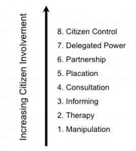
This desire for the empowerment of less privileged groups, coupled with 1990’s desk-top computer technology, defines the PPGIS process as a top down process where a central authority (i.e. government, researcher) identifies a problem, the best way to address the problem, and who can be granted access to the process to achieve the desired outcomes (Carver et. al. 2001).  As such, PPGIS is a multi-dimensional entity whose core components include notions of ‘public’ and ‘participation’, but are poorly defined in the literature. In fact, it is a 1960’s model of Citizen Involvement.  The following is Arnstein’s (1969) Ladder of Citizen Control most often used in the PPGIS literature.

Arnstein’s Ladder of Citizen Control

It is the notion of Social Computing that sets the GeoWeb and Citizen Science on a collision course.  Social Computing exists in contrast to the closed networks of the PC era, and can be defined as the ability of users to create, interact with and manage an information space that is dynamic, socially collaborative, portable and location sensitive (Parameswaran and Whinston, 2007). Social Computing is the technology that allows us to connect everything to everything (Hudson-Smith, et. al., 2009) in a network whose value increases as its membership increases (Benkler, 2002). As more members and devises connected to the network, the larger the information circle any one individual has.  This, coupled with enhanced communication predicated on mobile devises that can record and transmit spatially and socially relevant data, potentially challenges established power structures and traditional modes of citizen engagement with an authority driven process, such as PPGIS.

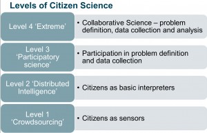
Social Computing facilitates a collision between the GeoWeb and Citizen Science by enabling citizens to participate more fully in the scientific process.  Muki Haklay, proposed the levels of Citizen Science found in the Figure below. In this model Level One defines the citizen as a purveyor of volunteered geographic information (VGI) where the citizen provide observations or sensor data to a scientific process.

Levels of Citizen Science from Muki Haklay, 2011

Level Two sees a citizen or a group of citizens act as interpreters of the data; in Level Three a citizen participates with a scientist in the problem definition and defining the data collection plan, and finally; Level Four sees the citizen working in collaboration with the scientist, even parallel to the scientist, where the citizen decides on the problems and methods to achieve a desired outcome.

Integral to this process is the fate of the data that citizen scientists provide to a process.  My next post in this series will develop these ideas further and provide some examples of Citizen Science in action, including an air quality monitoring pilot project in development in Edmonton.

References:

Arnstein, S. R.,  A ladder of citizen participation. Journal of the American Institute of Planners, 35(4):216– 224, 1969.

Benkler Y. Coase’s penguin, or, linux and the nature of the firm. 2002.

Carver, S., Evans, A., Kingston R., and Turton, I.. Public participation, gis, and cyberdemocracy: evaluating on-line spatial decision support systems. Environ. Plann. B, 28(6):907–921, Jan 2001.

Hudson-Smith, A., Crooks A., Gibin M., Milton R., and Batty M. Neogeography and web 2.0: concepts, tools and applications. Journal of Location Based Services, 3(2):118–145, Jun 2009.

Longley, P. Geographic Information Systems and Science. Wiley, 3rd edition, 2011.

Parameswaran, M. and Whinston, A. B. Social computing: An overview. Communications of the Asso- ciation for Information Systems, pages 762–780, 2007.

Schroeder, P. Criteria for the design of a gis/2., 1996. 

Sieber, R. GIS implementation in grassroots organizations. Urban and Information Systems Association Journal, 12(1):15–29, 2000.

Sieber, R. Public participation geographic information systems: A literature review and framework. Annals of the American Association of Geographers, 96(3):491–507, 2006.

It is very troubling when the nation’s top data producing agency squashes debate and pretends that the data it is producing is ‘methodologically sound and scientifically valid’ and communications departments call the shots while scientists, methodologists and subject matter specialists are silenced.  The governments is promoting transparency on one side (e.g. open.gc.ca), Canada has signed onto the Open Government Partnership, and government websites have proactive disclosure links, all the while transparency is not culturaly normalized in government institutions and management structures.

This is where ‘real’ transparency needs to occur, otherwise what is the point of a democracy when telling the truth is a carreer limiting move.  I do not want to live in a culture of yes people, divergent views is where we learn, test and re-evaluate.

Thanks to the resignation of the chief economic analyst at StatCan, at least we now know why non custom and non small geography national household survey data will be free – it ain’t good data! Sor much for open data!

Open data includes access to good data, and transparency means more than the disclosure section on a government website.  It is also interesting
that the 10 principles of open data all us open data enthusiasts quote do not include a principle on ‘quality, reliable, accurate and authentic data’.  I think it is time for a new principle and for some government principles.

We know that Philip Cross adheres to and understands both and it is a shame that good and smart people have to resign for us to hear what is really going on.  I want a government full of smart people doing the right thing according to their mandates and the ethical standards of their professions and disciplines.  To me that is just plain part of good governance.  Othewise, how can we trust what the government produces.  Honestly, I do not want to distrust the Canadian government, I live in Ottawa and I know lots of good people with integrity who are the best we can ask for in a public servant, unfortunately for them, the climate they are working in is testing their resolve, and people are keeping their heads low.

My faith in government keeps being tested these days and I fear that this new culture of yes people will be the new norm, which may perpetuate mediocrity and ill informed decision-making, which is unfortunate for us all as we have a great country, and it would be great if it could be governed by great people who can take us to greater and better heights, instead of great people who cannot tell the truth and by not doing so mislead us all.

Globe and Mail Article: Statscan’s chief economic analyst quits

Why Canadians Should Participate in the SOPA/PIPA Protest and what you can do.  (via Michael Geist)

Here is a list submissions that I will update as information comes in:

  1. CIPPIC Submission: CIPPIC Participates in the Open Government Consultation
  2. CPScpsrenewal (Nick Charney): Submission
  3. Mike Kujawsky: Submission
  4. The Imaginary Journal of Poetic Economics (Heather Morrison): Submission
  5. datalibre.ca (Tracey Lauriault): Response
  6. David Eaves: Submission
  7. Herb Lainchbury: Submission
  8. BC Fredom of Information and Privacy Association: Submission

Aggregation of tweets from the Open Government Twitter town hall:

  1. thumbtackhead.ca 
  2. Science Library Pad (Richard Ackerman): Canadian #opengovchat – archives & hackfests

Below is my response to the Open Government Consultations. I look forward to the government follow-up.
*******************
1. What could be done to make it easier for you to find and use government data provided online?

Each government department, crown corporation and agency should have a chief data officer (CDO) responsible for implementing opendata and opengovernment policies.  CDOs would be the institution’s data subject matter specialist, answer to the public and government.  CDOs would conduct an inventory of their data and information assets and these would be catalogued in a portal linked from their home pages but structured to also be federated into an opendata portal (ODESI).

Data catalogs would provide multiple ways to find data (Discovery Portal) and point to existing non-government initiatives (WEHUB, Community Data Program) as these are established communities of practice.  Building on best practices and existing models is efficient and interoperability should be the focus instead of homogenous data dissemination models.

Policies and practices should be developed in consultation with the nation’s experts (librarians, archivists, scientists, geomaticians), knowledgeable citizens and opendata advocates. Users should also be consulted and different data dissemination models may be needed for different levels of users.  Also, it is a good idea to build on already completed government consultations: Research Data Canada Consultation , Library and Archives Canada and Industry Canada.  There is also benefit in enlisting multiple sectors and not just the opendata consitutuents such as: Canadian Council on Social Development & community groups, Federation of Canadian Municipalities & cities, Publich Health Agency of Canada & health agencies, HRSDC & social sector, Open Data Cities, etc.

Government funding should mandate that the results of all publicly funded research be deposited into a trusted digital repository (TDR), in a data archive or portals (International Polar Year project & CIHR Open Access Policy).  Other areas of research focus could be data visualization products, building data use capacity, and understanding evidence based public participation.  Developing best practices for government to incorporate volunteered geographic information, citizen science and indigenous knowledge should be also be encouraged.

All agencies should be implementing TBS record’s management policies and its directives while also depositing their data and publications in the Depository Service Program (DSP) and Library and Archives Canada (LAC).  LAC & the DSP should be funded to develop a data archive as Canadians currently rely on the US funded and based Internet ArchiveResearch libraries should continue to develop distributed publicly accessible TDRs, cloud computing and broadband infrastructure to carry out their work.

Data should be aggregated into geographic units of utility to a variety communities, framework geography files (Geobase) and should be made available and data conversion services provided (GeoConnections):

  • StatCan DA, CT, CD, CSD, CMA
  • Health Districts & Sub Districts
  • City wards and neighbouhoods
  • Rural & Postal geos
  • Provinces, Territories & districts

Government should be engaged in creating ways to visualize data and provide some analysis. The Atlas of Canada could be the map window for data, each department could have a section devoted to their respective areas providing educators and the public with a trusted and authoritative reference in addition it would be a window into the geography of government policy.  Each agency could be assisted with the creation of infographics and apps to communicate programs and services by involving the public, private sector and universities and funding this would help grow a cadre of Canadian experts.  Research funds and CFPs would help produce tools (Many Eyes), apps (Budget Plateau), visual communication system (cybercartography) and social media processes. Transdisciplinary research can help develop the theory and practice of data communication while open tender can resolve specific data dissemination issues, develop relevant products and services.

Cost recovery should also be abolished and data procurement processes would also have to be evaluated ensure that government purchased data can be made available to the public.

2. What types of open data sets would be of interest to you? Please pick up to three categories below and specify what data would be of interest to you.

Other: See response to 1. & include all government deparment, crown corporations and agency program, administrative, research data including their related information products.

3. How would you use or manipulate this data?

I will provide a list of examples of government, communicy and citizen science data put to work:

Atlas of the Risk of Homelessness
WEHUB (Water and Environmental Hub)
Revealing Economic Networks
Portrait des communautés de l’outaouais
BC Hydraulic Registry
Evidence Based Decision-Making
Funding
Open Data for the Oil and Gas
Social Justice Reporting
Inuit Sea Ice Use and Occupancy Project (ISIUOP)
Atlases
Espace Montréalais d”information sur la Santé
Community View Collaboration
Community Information and Mapping System (CIMS)
Social Planning Council of Ottawa Data and Information Reporting
Social Planning Council of Winnipeg Poverty Profiles
Report Cards on Children’s Well Being
Social Planning Council of Hamilton Reports
Community Development Halton – Community Lens
Sault Ste. Marie Innovation Centre information products
– Electoral accountability – How’d They Vote? – , for youth  and many others
– Citizen Science –  Birders and Water
– Environmental Conservation – Waterly
Participatory Planning
Environmental Accountability
Ecological Footprint
Participatory Budgets
APPS
Citizen engagement
Lovely visualizations

4. What could be done to make it easier for you to find government information online?

See response to question 1. and 3.

The data and information discussed in this question, including FOI request results can also be disseminated in portals and be catalogued as was done with CAIRS.

The creation of suitable ways to communicate and visualize those data would greatly enhance information usability and information uptake.

Supporting Canadian entrepreneurs and researchers to develop tools (aka apps) to interact with and visualize these data and making those tools, apps and dbases available to the public would be beneficial (e.g. How’d they Vote or BudgetPlateau).

Fund data visualization in Canada and research into the use of data and public engagement.

5. Of the items below, which are the priority areas of information that you would like to see released on government websites:

Other, All of the above, essentially, all public sector information and data that are not private, that inform programs or that are collected as part of the governing process

6. In the past five years, have you participated in any Government of Canada consultations with Canadians?

Yes

Overall, how easy or difficult was it to: (very easy to very difficult or n/a)

    • Find out about Government of Canada consultations?
        • easy
    • Participate in Government of Canada consultations?
        • Somewhat easy but too constrained by format and pre-prescribed questions.
    • Use social media/Web 2.0 tools to participate and provide your input?
        • Easy, however, well facilitated round tables and face to face consultations with specialist communities are also important.
    • Obtain information about the outcome of the consultation you participated in?
        • Very difficult, there is rarely follow through.

7. Do you have suggestions on how the Government of Canada could improve how it consults with Canadians?

National round tables and outreach to specialist communities would be a start (e.g., health, social policy, science, industry, etc.), not just via social media but the actual organizing of face to face meetings that are well facilitated.  The National Research Council in the US does this (e.g. CyberinfrastructurePolicy and Science or Transportation) and makes available the results in the National Academies Press.  The US NRC gathers experts to define problem areas or forecast needs (e.g., Cyberinfrastructure), collaborate to develop solutions and then the Council actually develops CFPs to implement proposed solutions.  We could actually mobilize the nation’s experts in Canada, not just the nation’s consulting firms to help develop creative solutions.

GeoConnections, StatCan, Library Archives Canada and The National Research Council of Canada have had experience conducting public consultations, round tables and summits with data users, producers, managers and specialist communities.

Those engaged with public participation researcher have expertise here, as do those engaged in action research or public participation GIS.  Organizations that have developed ChangeCamps, GovCamps, hackfests and citizen city open data communities are another groups that have experience and proven expertise in carrying out creative consultations.

Some tables already exists such as Community Data Canada  and the Community Data Program on the social sector side, the FCM for Cities, Open North  for open data advocates and entrepreneurs, city Open Data Groups, CODATA in Science and numerous academic and professional associations such as IASSIST, ACMLA, CAPDU, CARL, as well as subject matter specialists in demographics, public health, community informatics, etc. There are also a number of important lists such as civicaccess.ca where various communities of interest are engaged and intersect.

It is important to work with data specialists, engineers, scientists, apps developers and it is equally important to outreach with heavy data and information users such as journalists, researchers, consulting firms, utilities, community organizations and cities to understand their needs.  Conducting user needs analyses is another useful way to engage with people.

8. Are there approaches used by other governments that you believe the Government of Canada could/should model?

See response to 7, and 1.

9. Are there any other comments or suggestions you would like to make pertaining to the Government of Canada’s Open Government initiative?

An open government initiative needs policy and directives to ensure, guide and involve the governors and bureaucrats.  Open government also requires cultural change and it also means that the government will need to welcome citizen participation and govern based on evidence from within government and based on the work done by citizens.  It is not suitable to open government and share data and then cut funding in research, libraries, archives, think tanks or the census.  Open government means nurturing and growing a multifaceted knowledge industry and volunteer sector on topics ranging from spending, women, poverty to infrastructure and government administration.  It also means welcoming informed results irrespective of their alignment with the ideologies of the government of the day.

The culture of secrecy regarding submissions to cabinet, MOUs, and so on should also be reconsidered as the public has a right to know upon what government is basing its decisions.  The Government of Canada already has excellent regulation, directives and policies regarding access to information, records management and archiving, and these need to be funded and actually implemented.  These should not be circumvented as seen in the case of the gun registry bill where there was a clause precluding archiving and preservation of the data it contained.  That makes for inconsistent policy.  Government should also be at arm’s length from its data gathering agencies such as Statistics Canada, the cancellation of the Census has garnered much public distrust and also puts in question the impartiality of the data, the recommendations of the National Statistical Council on this matter should be implemented.  Organizational and cultural change is also required, and we should allow our expert public servants to speak freely and authoritatively and not quash their views even if not in accordance to a minister’s preferences, (e.g., scientists).  Communication’s departments should be facilitating communication and not controlling it nor be the source of wisdom and knowledge about government work.  Also, consultation needs follow through, otherwise it is wasted effort and we should be building upon the results of previous consultations and not continuously reinventing the wheel.  Consultations should also include some sort of benchmark system to assess whether or not government is actually following through on its policies.  A brief examination of departments and their data preservation practices will demonstrate that in fact most departments are not, cannot and will not meet directive requirements on records management and preservation policies.  What is the point of policy and directives if not implemented!

Open government is more than a portal, as the Information Commissioner’s Resolutions have clearly stated, it is also about changing the way work is done and being more responsive to citizen input, more welcoming of divergent and conflicting views and includes greater, deeper, real and more meaningful public engagement.

10. How would you like to stay connected to Canada’s Open Government initiative?

    • Web updates (email alerts)
    • Public Consultation

Thanks to James for helping me find lost responses!

I met Terence Gannon at the Cybera Summit 2011 in Banff of this year and was most impressed with his open data business model and invited him to prepare a guest post. Here is the link to the video of that presentation.
*****************************

Many efforts to open up public data stores are oriented to the noble but somewhat non-specific goal of more open and transparent public governance.  Intellog Inc., founded in  2008, has a different objective; to use public data as a substrate for building a profit-oriented, job-creating, taxpaying business.  With over three years of experience under our belt, we now wonder if it would have been easier to choose a more conventional path.  Here’s the cautionary tale.

Intellog’s primary business objective is to bring the current generation of Internet technologies to the oil and gas business.  Our first project was to address a surprising lack of a robust, open and systematic way of identifying petroleum wells in the Western Sedimentary Basin.  The solution seemed obvious, so we were surprised when we discovered putting together such a list had not been undertaken to that point.  Our subsequent experience with provincial regulatory agencies — the current stewards of this data — eventually provided us with the reason why.  Saskatchewan is superbly well organized, helpful and knowledgeable staff.  Alberta is at the opposite end of the spectrum, cursed with a toxic combination of creaking, antiquated systems and intransigent leadership. The other jurisdictions fall somewhere in between but are generally pretty good.

In short, nearly four years later, we still don’t have standardized, open well identification to support the development of innovative, revenue-generating applications. We continue to pursue access to the requisite data through the Freedom of Information process which is now due to conclude in March, 2012 — nearly four-and-a-half years since we started down this path. In the interim, the closest we have come is three, competing proprietary datasets owned by private companies, one of which is US-based.  These companies are at liberty to pick and choose their partners and have therefore become the unaccountable, de-facto regulators of innovation.  Want to build the next great application for the oil & gas industry?  Be prepared to make some sort of deal with one of the three incumbent data vendors, and have your cheque book ready. In reality, this first obstacle proves fatal for virtually all start-ups.

Secondly, the inherent ‘goodness’ of open data and the positive light in which it is typically viewed doesn’t substitute for a marketing strategy and creating products your prospective customers want to buy.  There is no such thing as a principled purchase — buying happens when product capability meets excruciating business pain and sometimes not even then.  When we rolled out some initial portions of the open well data, you could have heard a pin drop — our prospects simply did not care, because it did not solve a problem they perceived they had.  Oil & gas companies, particularly publicly traded ones, think in fiscal quarters, so if open data and the applications that use it don’t return measurable value in the very short term, they’ll sit on the shelf unloved and ignored.

Finally, the same reasons which motivate us to use open data, tend also to motivate the use of open source software.  Our experience over the past few years indicates that open source alternatives to commercial products are, without exception, as good and in most cases better than their proprietary equivalents.  Support, albeit of the self-serve variety, is also better, with mainstream open source projects surrounded by enthusiastic and helpful communities.  But we weren’t prepared for the objection along the lines of “we are a .NET/Oracle/etc. (or whatever) shop” being a reason for passing on our product offerings. And yet sometimes that seems to be the case.

The main lesson hard won over the last three years is that a successful venture is built on “customers first, everything else tied for last”.  Building great products and providing outstanding customer support — using whatever set of tools — will eventually get you the  success you want and deserve.  Open source data and development tools can keep costs down and have other attendant benefits, but they are not an end unto themselves.

Bio: Terence Gannon, Founder and President at Intellog Inc. launched his first start-up in the early 1980’s, bringing two word processing programs to the nascent personal computer market. He has since served stints at North Canadian Oils, Norcen, Sceptre Resources, Canadian Fracmaster and Trican Well Services, where he pioneered the use of ultralight business process management tools to increase productivity, and reduce missed or duplicated work. In 2008, Gannon launched Intellog Inc. with the mandate of bringing current generation web-based applications and data integration tools to the oil and gas industry. He regularly campaigns for the petroleum industry to open up its public data stores to be free and widely available to all stakeholders.

« Older entries § Newer entries »