geo

You are currently browsing the archive for the geo category.

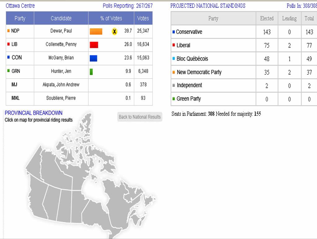
I was looking for maps all night on the Tele!  None appeared so I came home and found a few.   I wonder if the cost and license restrictions of the actual electoral boundary file was an issue for television networks and the media.  The only institution that provided a map with ridings was CBC. The rest were visualizations or shell maps of provinces and territories.

The CBC maps were interactive, with roll overs pop ups and some zooming capabilities!  As I predicted before seeing the maps, multicoloured areas are urban, west is blue with some patches of orange, centre is orange, east is baby blue, with some patches of red and blue, and all those country ridings are tory blue!  And Ottawa, which I did not predict, is surrounded by blue, with one orange and 2 reds!  Ontario, well, it is awfully blue!  Kinda fun to look around to see what is up!

CyberPresse has a pretty interesting visualization!  One cannot see the real geographic distribution of the results but it remains a creative and interactive way to see the votes!  As you scroll over the little squares a pop up window shows the results!  At a glance a user can see the number of seats per province and then look at the littles squares and their colours, this was perhaps a little less effective but I guess they were struggling with screen real estate and access to a base map.

CTV had a pretty rudimentary map of the provinces and territories.  If you click on the province you get a window of the ridings and a rather garish obtrusive list of ridings that blocks the map.  You select the riding and then you get the results of the province in a table but not a geographic distribution of results by riding.  The map is then left at the bottom of the page all lonely with not much information associated with it.
The Globe and Mail also had an interactive map but again just a shell with the provinces and territories like CTV example above, with a small bit of scroll over action that yields a pop up window and the left pane changing on the right.  Informative but not the big picture of the country like a map with all the ridings.

Finally there is our national institution, Elections Canada!  A few minutes ago it had no results! Oh My!  No maps, and not the most intersting way to access the info. I wonder if they will ever produce a map?  Will it be more than a static PDF? Since they own the base file you’d think they could do a little something with that monopoly access?  Or perhaps because Statistics Canada sells that for them they also have some sort of dissemination restrictions.

From gasbuddy.com:

Now you can see what gas prices are around the country at a glance. Areas are color coded according to their price for the average price for regular unleaded gasoline.

Here is the US map.

[via infoesthetics]

The Socio-Economic Impact of the Spatial Data Infrastructure of Catalonia

Pilar Garcia Almirall, Montse Moix Bergadà, Pau Queraltó Ros
Universitat Politècnica de Catalunya
Centre of Land Policy and Valuations

M. Craglia (Editor)
European Commission
Joint Research Centre
Institute for Environment and Sustainability

This study gathered information and data from:

a sample of 20 local authorities participating in the Catalan SDI (IDEC) together with 3 control local authorities not participating in the SDI, and 15 end-user organisations, of which 12 are private companies operating in the Geographic Information (GI) sector, and 3 are large institutional users of GI. The findings of the interviews were presented in two separate workshops to the participating local authorities and end-user organisations, to validate the findings and discuss the outcomes.

Here are some of the findings:

  • main benefits of the IDEC accrue at the level of local public administration through internal efficiency benefits (time saved in internal queries by technical staff, time saved in attending queries by the public, time saved in internal processes) and effectiveness benefits (time saved by the public and by companies in dealing with public administration).
  • Extrapolating the detailed findings from 20 local authorities to the 100 that participate in the IDEC, the study estimated that the internal efficiency benefits account for over 500 hours per month. Using an hourly rate of €30 for technical staff in local government, these savings exceed €2.6 million per year.
  • Effectiveness savings are just as large at another 500 hours per month. Even considering only the efficiency benefits for 2006 (i.e. ignoring those that may have accrued in 2004-05, as well as the effectiveness benefits), the study indicates that the total investment to set up the IDEC and develop it over a four year period (2002-05) is recovered in just over 6 months.
  • Wider socio-economic benefits have also been identified but not quantified. In particular, the study indicates that web-based spatial services allow smaller local authorities to narrow the digital divide with larger ones in the provision of services to citizens and companies.

The study is methodologically heavy toward quantification of cost savings with some information pertaining to access to information and civicness associated to an increase in access to data.  It is mild on the latter, primarily because this is hardest and most subjective of measures.  But then again so is justice, equality and the good life.  I appreciate the quantification of costs, it makes the bean counters happy, I would however like to see more civicness measures and philosophical reasons for more access. I think that would lead to the creation of civic access measures.

btw – I have been a big fan of the editor of this report for years.

I am doing some work looking at broadband maps and atlases. I started off with a trip to the Carleton Map library, I followed some very knowledgeable map librarians around and picked up a huge roll of paper maps to begin exploring this new subject. I discovered an excellent little folding paper map on Digital Inclusion. As I was looking at its sources I discovered that this map was part of a broader and very exciting online Atlas project that includes numerous map themes on social justice, environment, health, etc.

I like these maps because they are aesthetically pleasing, are accompanied by a table of content explaining the themes and indicators represented, and with data sources (aka metadata) that are made obvious and easy to understand. Each map w/its associated information is an overview of an issue. There are membership requirements to access additional data related to the maps. http://maps.maplecroft.com/

http://maps.maplecroft.com/
Finally, this company has an interesting business model. The publication of the paper map was sponsored by Alcatel and is a superb information marketing tool at conferences, the UN, WDB, ADB, OECD etc. It is also excellent swag. Maplecroft is also

a successful specialist research and advisory company focused on the non-financial performance of large multinationals. It has a strong corporate client base and research partnerships with leading international organisations, such as those within the auspices of the United Nations, the World Economic Forum and prominent independent non-governmental organisations.

Maplecroft has developed particular expertise in strategy, management systems, indicators, cross sector partnership building, stakeholder engagement, audit, and risk management. It has a specific interest in cross sector engagement.

Primarily a commercial organisation, Maplecroft has formed and facilitated several strong multi-lateral partnerships with business, lobby groups and aid organisations for mutual benefit. It fundamentally operates as a social enterprise, whereby non-profit partner organisations gain from commercial engagements it may form. Maplecroft undertakes a great deal of pro-bono work, and seeks opportunities to contribute to the initiatives with which it becomes involved.

The cost of producing the high quality maps and associated information seen here is in the hundreds of thousands of dollars, the technology is the easy part, it is the cost of the minds and data associated with knowledge production and the maintenance of a reliable and trustworthy product that is really high. Few organizations beyond government can take on this sort of project on. It is most certainly an interesting and ethically driven business model.

1. The Value of Spatial Information (Exec. Sum, Full Report) a ACIL Tasman report commissioned by the Cooperative Research Centre for Spatial Information (CRCSI).

2. the 1999 Oxera Report (Oxford Ecomomic Research Associates Ltd.) commissioned by the UK Ordnance Survey.

3. U.S. CODATA Reports published by the National Science Foundation (Free to read online)

4. The European Commission GI and GIS – Documents

5. Commercial Exploitation of Europe’s Public Sector Information, PIRA International study of 2000, Summary, Full Report

There is a very good discussion on how to deconstruct and compare the methodologies and results of the two first documents on the GSDI Legal and Economic Working Group Discussion List. This list has some of the top thinkers in the field of data access from an academic, legal, scientific and public institution standpoint. The list includes an archive that is well worth searching if ever looking for resources on this topic and to hear folks debate the details of these and many other data related issues.

Coalition Casualty Count is a site managed by independent US citizens who analytically count the coalition casualties

for Operation Iraqi Freedom and Operation Enduring Freedom [Afghanistan]. We attempt to be up to date, precise, accurate and reliable.

There are many other sites on the web that list information of Fatalities from Iraq , but few if any of them do this in an analytical fashion. We endeavor to provide not just a list of names but a resource detailing when, where and how fatalities occurred.

You can read their methodology here.  I am always happy when I get to see the data and read how they were assembled, this provides me with the means to critically assess what is being presented to me.  I love the myriad visualization tools that are emerging on the net however, I wish they were accompanied by metadata which helps me better understand and decide whether or not I trust what is being said to me.

There are alot of data points and even some maps on this site and these folks are commended for doing this work and telling this important story.  There is also a list of the Canadian men and women causalities in Afghanistan.

via: Spatial Sustain

I discovered a very nice 4 pager primer on access to satellite and radar data prepared by Athena Global. The paper explains that EO data (satellite and radar) policy is the set of public decisions and guidelines about:

• what data will be produced or purchased;
• how it will be managed and by whom;
• who will have access to it (availability, confidentiality);
• how the costs of data will be paid;
• the price charged to users;
• who makes these decisions and through what processes.

The paper also discusses how Canadian EO data is determined by the type of sensor, whether it is framework data or specialized data, by who is asking for or wanting to purchase those data and that data policy has an impact

on data usage, and consequently on the integration of EO information into applications, products and services. In this way data policy shapes the potential promise of space programs in EO.

This is the direct link to the innovation rhetoric we are constantly bombarded with and to the argument that the private sector will flourish in interesting ways if data are made available to it and most importantly the direction of an entire industry. The paper also includes the following which is an excellent way to think about data pricing and its effects:

  • A direct association exists between pricing and its effects on public access and commercialisation of government agency information. Current pricing problems are having a deleterious effect on the affordability of spatial data in Canada, France, and the United Kingdom;
  • A direct association exists between the application of intellectual property rights and the degree of public access and commercialisation of government agency information. The greater the restrictions on access, the less successful dissemination programs will be;
  • Reducing prices and relaxing intellectual property restrictions on government datasets are significant factors improving opportunities for access and commercialization for stakeholders in the geographic information community.

The organization also prepared a brief on ways to think about EO users, and it may be a nice way for CivicAccess.ca to think about when framing debates around citizens and who and what their interests are.  EO users are viewed from the perspective of consumers, patrons and partners while recognizing there are different types of users:

scientific, commercial and operational (government, IOs NGOs, universities, research institutions, companies) that have different characteristics and technical skills, different data needs (long term – short term, information – data) and use data for different types of applications.

The paper explains the EO data use obstacles related to how the data are delivered, cost, lack of knowledge, and so on.  In essence the paper argues to match data supply with data needs.

Data Policy and Engaging EO Users by Athena Global.

New Cartographers

Great article, The New The New Cartographers, by Jessica Clark, from In These Times:

Maps are everywhere these days. The ubiquity of global positioning systems (GPS) and mobile directional devices, interactive mapping tools and social networks is feeding a mapping boom. Amateur geographers are assigning coordinates to everything they can get their hands on—and many things they can’t. “Locative artists” are attaching virtual installations to specific locales, generating imaginary landscapes brought vividly to life in William Gibson’s latest novel, Spook Country. Indeed, proponents of “augmented reality” suggest that soon our current reality will be one of many “layers” of information available to us as we stroll down the street.

[more…]

A great map of Australia, as seen by traditional aboriginal tribes. I can’t imagine the Canadian government doing something like this.

One curious note, below the map, the fine print says:

Disclaimer and Warning: Not suitable for use in native title and other land claims

[via: foe]

Check out what open public transit data is available in Finland:

http://transport.wspgroup.fi/hklkartta/

I suspect a small minority of transit authorities in Canada may actually have GPS units on board buses, but I haven’t heard of any making the data publicly accessible — and not in such fine form. This is really beautiful to see, but it fills me with shame that we are light-years behind.

Original article in the Guardian:

http://www.guardian.co.uk/technology/2008/feb/28/research.transport

Is anyone aware of any real-time data being made available in Canada?

« Older entries § Newer entries »